

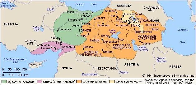
Historical Armenia according to the Encyclopaedia Britannica
A map of historical Armenia according to the Encyclopaedia Britannica. Orange marks the territory of Greater Armenia, green Byzantine Armenia, violet Cilician Armenia, and yellow the territory of today’s Republic of Armenia, which the map legend calls Soviet Armenia.
The map shows the cities of historical Armenia, Lakes Van and Urmia, and the neighbouring countries and seas, while a dashed line marks the boundary drawn by Woodrow Wilson for the Treaty of Sèvres (10 August 1920). The year 1994 is written in the lower right corner.